6월, 2023의 게시물 표시

Pyvista

https://banesullivan.com/pyvista/examples/index.html 

Gempy: critical points

Reference: https://docs.gempy.org/getting_started/get_started.html#sphx-glr-download-getting-started-get-started-py *GemPy core code is written in Python. However for efficiency (and other reasons) most of heavy computations happend in optimize compile code, either C or CUDA for GPU. To do so, GemPy rely on the library theano. To guarantee maximum optimization theano requires to compile the code for every Python kernel. *GemPy is a surface based interpolator . This means that all the input data we add has to be refered to a surface. The surfaces always mark the bottom of a unit. By default GemPy surfaces are empty: *It is decisive to remember that, in GemPy, interface position points mark the bottom of a layer.  *GemPy input data consist on surface points and orientations (perpendicular to the layers)   *As we generate our Data from CSV-files, we also have to define our model's real extent in 𝑥 , 𝑦 and 𝑧 , as well as declare a desired resolution for each axis. This res...

np.ravel_multi_index

GPR siganl processing: AI

  *coherent 노이즈 (Clutter) 제거 기계학습이 통계적 분포를 이용하여 데이터를 학습한다면 Radar clutter도 통계적 분포가 있는데,  기계학습이 Radar clutter 억압에 기여할 수 있을까? *incoherent 노이즈 제거 GPR signal processing이 기계학습으로 대체 가능성이 있을 까? 현재, 노이즈 억압을 위해서 시간을 들여 stacking을 하고 있는데, 이러면서  측정 영역이 좁아 진다. 그렇다면, 기계 학습을 이용해서 노이즈 억압을 하여 측정 영역을 넓힐 수 있을까? *Noist2Nois 모델은 다른 나라에서 공개한 행성탐사 자료에 활용할 수 있지 않을까? 특히, 시계열 원시 자료를 확보하기 힘든 LRS 자료의 경우 말이다. 

Geoscience AI

  모든 분야의 데이터들이 저마다의 특성이 있으나 인공지능 적용 분야에 있어 ,  지질자원 분야의 데이터들은 일반적인 데이터 특성과는 달리 조금 더 구별되는 주요 특성들을 가지고 있다 .  제조 · 생산 분야에서 정기적 ,  주기적으로 획득되는 팩토리 데이터와 달리 땅은 획득할 수 있는 데이터 샘플이 양적인 측면에서 매우 제한적이다 .  땅이라는 대상의 특성상 다양한 잡음원과 불확실성 등 더티 데이터가 될 수 밖에 없다 .  위치 및 지역에 따라 그 통계적 특성이 매우 달라지는 데이터는 학습 모델의 일반화가 용이하지 않다는 점도 큰 어려움으로 작용한다 . 이러한 이질적인 데이터 환경으로 인해 래퍼런스 인공지능 모델들을 구조 변경 없이 적용했을 때 기대 이상의 낮은 퍼포먼스를 나타내는 경우들이 많다 .  어느 정도 성공적인 성능을 나타내는 모형들이 개발되었을 때도 이러한 모델들이 지질자원 분야 내에서 확대 재생산되지 않고 사장되기도 한다 .  이는 제조 ,  산업 분야 대비 인공지능 생태계가 잘 갖추어져 있지 못하다는 관점에서 바라볼 수도 있다 .  이는 비단 국내에만 국한되는 것이 아니다 . https://www.kigam.re.kr/gallery.es?mid=a10703020000&bid=0004&list_no=5192&act=view

GPR interpretation processing: Single Value Decomposition (SVD)

*직교 행렬 (orthogonal matrix) : 모든 Column 들이 orthonomal set을 이루는 행렬 -> orthogonal: 모든 column 벡터들이 서로 직교한다. 수식적으로는 내적 (inner product)이 0 이라는 것이다.  -> normal 모든 벡터의 크기가 1로 맞춰져 있다는 것이다.  Q = [q_{1}, q_{2}, \cdots q_{n}] \newline \\ (q_{i}, q_{j}) =\left\{\begin{matrix} 1 \ (i = j) \\ 0 \ (i \neq j) \end{matrix}\right. *대칭 행렬 (symmetric matrix) *반대칭 행렬 (skew symmetric matrix) *단위 행렬 Singular value decomposition can be used to compress images by truncating SVD matrices to lower dimensions. Since the components with the most important information are ordered to be in the front, we can use the first r rows and columns to compress an image to reduce not-as-important information in the picture, by truncating the SVD matrices to rank r . im reference:  https://m.blog.naver.com/crm06217/221723294379 https://darkpgmr.tistory.com/105 https://www.cs.cmu.edu/~16385/s17/Slides/11.5_SVD.pdf https://angeloyeo.github.io/2019/08/01/SVD.html https://angeloyeo.github.io/2020/11/19/eigen_dec...

GPR interpretation processing: Image_gradient

이미지
Image gradient: Gradient direction: Gradient magnitude: Convolution matrix Simple example (from GIMP) On the left is the image matrix: each pixel is marked with its value. The initial pixel has a red border. The kernel action area has a green border. In the middle is the kernel and, on the right is the convolution result. Here is what happened: the filter read successively, from left to right and from top to bottom, all the pixels of the kernel action area. It multiplied the value of each of them by the kernel corresponding value and added results. The initial pixel has become 42: (40*0)+(42*1)+(46*0) + (46*0)+(50*0)+(55*0) + (52*0)+(56*0)+(58*0) = 42. (the filter doesn't work on the image but on a copy). As a graphical result, the initial pixel moved a pixel downwards. reference:  https://www.cs.cmu.edu/~16385/s17/Slides/4.0_Image_Gradients_and_Gradient_Filtering.pdf https://www.cs.cmu.edu/~16385/...

GPR signal processing: Rarely does processing substantially change the interpretation

  Some final thoughts Warning: processing can introduce artifacts in the data and lead to wrong interpretations   What really matters is that the final interpretation is valid, and although processing is important, ultimately, the key to good data interpretation is good data collection in the first place. in Cassidy (2009) Chapter 5 - Ground Penetrating Radar Data Processing, Modelling and Analysis, In Ground Penetrating Radar Theory and Applications, (Eds Harry M. Jol,), Elsevier, Amsterdam, pp: 141-176, ISBN 9780444533487 .   A good practical mantra for most users to adopt is if it cannot be seen in the raw data – is it really there? As such, processing steps should be used to improve the raw-data quality, therefore, making interpretation easier . In practice, this means increasing the signal-to-noise ratio of coherent responses and presenting the data in a format that reflects the subsurface conditions accurately. in Cassidy (2009) Chapter 5 - Ground Penetr...
행성과학 세미나: Volcano on Venus

서울대학교 이현우 교수님 Key reference :  2022, Gillmann et al., The Long-Term Evolution of the Atmosphere of Venus: Processes and Feedback Mechanisms: Interior-Exterior Exchanges 2022, Gravin et al., Revealing the Mysteries of Venus: The DAVINCI Mission *Stagnant lid 또는 single plate의 지구조인 금성은 Hot-spot 과 관련된 화산활동이 주가 된다.  *금성의 대기 주요 성분 : CO2, N2, SO2 (황은 쉽게 reactive 한다) *금성에서 휘발성 기체의 교환 ->  Noble gass의 outgassing이 다른 행성체에 비해 덜하다. *금성 휘발성 기체의 Sink -> 표면과 가스의 반응 *금성에서 물의 역할 *금성에 과거에 물이 많았을까? 현장과 원격탐사를 통해 확보된 D/H ratio 가 지구의 200배 가된다. 물을 runaway greenhouse effsct로 잃은 것으로 설명 가능하다. 

Polarization

이미지
Reference: Lopez-Martinez and Pottier, Basic Principles of SAR polarimetry ,   Polarimetric Synthetic Aperture Radar (2021, Hajnsek and Desnos)   Definition of polarization  IEEE Standard Definition for Antennas (IEEE standard number 145 1983) Property of the radiated electromagnetic wave describing a time-varying direction and relative magnitude of the electric wave vector. =The  figure traced as a function of time by time extremity of the vector at a fixed location in space and the sense in which it is traced as observed along the direction of propagation. 

미고결층 분석 방법 및 기원지 분석

분석의 목적 해당 미고결 층은 모암의 풍화 산물인가, 아니면 외래성 퇴적물인가? (기원지 분석: 하상퇴적물의 주 공급원 (지화학적 접근 ) ) 위 질문에 답하기에 도움을 줄수 있는 근거가 무엇이 있을까? 입도 대자율 토색 유기물 함량 토양 발달 지수 전자스핀공명 (ESR) Y 값 (경험식) --> 위 분석들은 Dynamics한 환경에서는 활용이 어렵지 않을 까 하는 것이 나의 생각 내 생각에 활용가능한 분석 방법들 X 선 회절 : 광물 분석   주성분 분석 : 상대적 풍화정도 파악, 풍화지수 -> 주성분 성분의 경우 퇴적물의 운반과정에 따른 분급 작용 등으로 광물입자의 크기에 따라 조성이 달라지는 등의 변화가 일어나끼 때문에 기원지 암석과의 직접적 대비가 어려울 수 있다 (2003, 이승구 외).  미량원소 분석 : 상대적 결핍 부화정도 희토류 원소 분석 : 풍화, 속성작용에도 함량 변화 적음 (왜 분포 양상이 변하지 않을까?) , 퇴적층의 기원암 또는 기원지 추정에 사용 -> 희토류 원소는 일반적인 외적 요인에 의해서는 분포양상이 변화하지 않기 때문에 퇴적무물의 기원지 혹은 기원암을 추적하는 데 매우 유용하게 사용되어 질 수가 있다 (2003, 이승구 외).   분석에 필요한 기준 : PAAS (시생누대 호주 셰일), UCC(상부대륙지각), 운석(콘드라이트) 분석시 활용할 수 있는 Diagram 일반적으로 토양과 퇴적물의 화학 조성을 직접 조사하는 것은 무리다 (2003, 이승구 외). Al2O3 - CaO - Na2O - K2O - FeOt 의 조성비를 활용한 삼각도가 기원암과 풍화 연구에 많이 이용된다.  1. A-CN-K 2. A-CNK-FM 3. 산소동위원소 ( 18 O) :  분석에 필요한 기준 : 해수  참고 문헌 : 뢰스지형학 (윤순옥, 2022) 2003, 이승구 외, 희토류원소를 이용한 순창지역 섬진강 수계내 하상퇴적물의 기원지 연구 2005, 곽재호 외, 순창...

Micmac:question

이미지
 

지진파 용어 정리

이미지
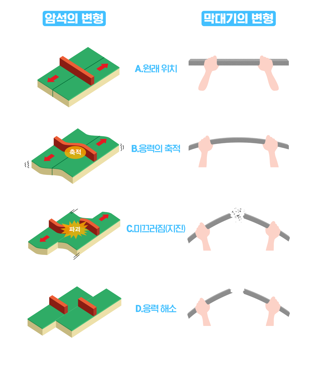
응력: 물질에 작용하는 단위 면적 당 힘 변형 : 부피나 모양의 변화 변형률 : 원래 길이 대비 변한 길이 변형률 속도 : 물질이 어떤 변형을 일으키는데 걸리는 시간 탄성의 정도 : 물질이 얼마나 지진파를 잘 전달하는가? 탄성거동 : 응력이 제거되면 물질이 본래의 부피와 모양으로 복원 되는 것  압축력 : 변형을 일으키는 응력의 크기와 방향 (압축력, 인장력, 전단력) (출처: 기상청 온라인 지진관) 탄성 한계 이전까지는 응력과 변형률의 관계는 후크의 법칙을 따른는 것을 잘 보여준다.  압축력과 변형률 속도 조건에 따라 지구 구성물질의 특성 (탄성 또는 비탄성)이 바뀐다.  예) 지진파의 경우 빠른 변형률 속도로 인해 약권은 탄성의 특성을 띄게 된다.      *한반도 응력 현황 : http://m.dongascience.com/news.php?idx=14043 출처: 기상청 온라인 지진과학관 https://www.kma.go.kr/eqk_pub/bbs/faq.do?fmId=1        

Geomorphology

이미지
 선상지 or Pediment (https://pubs.usgs.gov/of/2004/1007/fans.html) 선상지 곡부 (https://m.blog.naver.com/PostView.naver?isHttpsRedirect=true&blogId=justletme&logNo=150013009091) Advection : Advection is a lateral or horizontal transfer of mass, heat, or other property. Accordingly, winds that blow across Earth's surface represent advectional movements of air. Advection also takes place in the ocean in the form of currents. Figure 1. High‐relief, tapered topography featuring advection‐parallel interfluves in regions of gradually declining median Ksn in the direction of advection shown above proposed décollement geometries (as shown in McQuarrie et al., 2008; Whipple et al., 2016; Yue et al., 2005) using ASTER digital elevation models (~30‐m resolution; U.S./Japan ASTER Science Team, 2000), Ksn maps of fluvial channels and swath profiles across the Beni Escarpment in the central Bolivian Andes (a, AA′), Central Nepalese Himalaya (b, BB′), and the Peikang River region of Taiwan (...